2 Plate Tectonics
Nahgeib Miller
Learning Objectives
After completing this chapter, you should be able to:
- Describe the evolution of plate tectonics as a theory.
- Explain plate tectonics as an overarching theory that explains several geologic phenomena.
- Describe the types of plate boundary interactions and their resulting geologic features and phenomena.
The theory of plate tectonics states that the crust (lithosphere) of Earth is broken into 12 major plates that float on top of the upper part of the mantle, called the asthenosphere. The asthenosphere (from the ancient Greek word for “weak,” asthenos) extends from about 100 km deep to about 700 km deep and is hotter and more fluid than the lithosphere. The plates move under the influence of convection currents in the mantle, which causes them to move toward, away from, and past each other. This movement and the interaction between the plates give rise to several geologic phenomena, including mountain ranges, island arcs, deep-sea trenches, earthquakes, and volcanoes.
2.1 The Evolution of Plate Tectonics as a Theory
Continental Drift
Before the promulgation of plate tectonics as a theory, separate theories were advanced to explain the existence of volcanoes, earthquakes, mountain ranges, island arcs, and many other geologic phenomena. These theories were unrelated to each other and, therefore, plate tectonics is seen as a unifying theory.
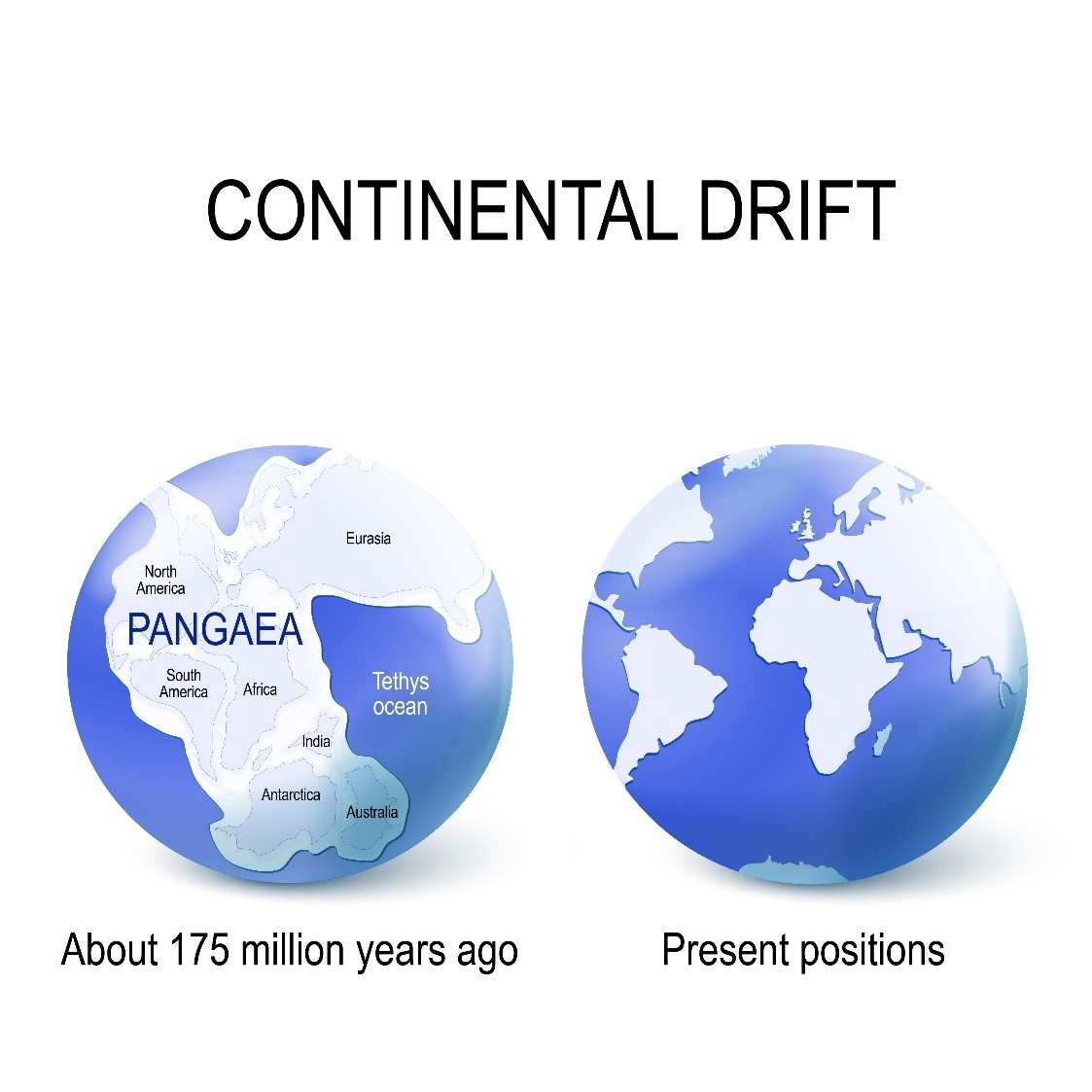
The first steps toward this unifying theory were made by Alfred Wegener, a German meteorologist and geophysicist. During the early 20th century, he and several other scientists noticed that the outlines of the continents seem to fit together like a jigsaw puzzle. However, he was the first to present a coherent hypothesis in his 1915 publication The Origin of Continents and Oceans. Wegener used the jigsaw fit of the continents and the similarity of rock strata (rock sequences) and fossils found on opposite sides of the Atlantic Ocean to develop his hypothesis. He postulated that all the continents were once joined together in one continental body called Pangaea and subsequently drifted apart into the positions we see today in a process we call continental drift. However, Wegener was not able to adequately explain where the immense forces required to move continents came from. His hypothesis was rejected by the scientific community until the 1960s, when it gained prominence as part of plate tectonics (Figure 2.1).
Although Alfred Wegener’s hypothesis was abandoned, research continued into his assertions of the similarity of fossil and rock assemblages on continents on opposite sides of an ocean. Rock assemblages are rocks that were laid down in a specific sequence, indicating a specific sequence of geologic processes acting in specific depositional environments. How specific all this is means that the likelihood of this sequence occurring anywhere else, independently on Earth, is remote. Therefore, any similar rock assemblages must have occurred in the same place and then moved apart to where they are found today! The same is true of fossil assemblages: specific grouping of fossils in the rock record. Because a grouping is dependent on so many inherent factors, such as the plant’s or animal’s living environment and the depositional environment, it is unlikely that all these factors could come together in the same way in different parts of the globe. It is far more likely that the plants and animals in the grouping were fossilized in the same place and subsequently drifted apart.
In fact, it was found that the rock assemblages on the eastern coast of South America were similar to those on the western coast of Africa. Also, rock assemblages in northern North America matched up with those in Greenland and Scandinavia. Furthermore, the fossil assemblages are similar up to about 200 million years ago. From 200 million years ago to the present, the fossils’ morphology diverge! This observation reinforces the continental drift hypothesis because the breakup of Pangaea is postulated to have occurred about 200 million years ago. That means the environments where these now fossilized plants and animals would have evolved, lived, and died would now be increasingly different.
One key fossil is that of mesosaurus, which has a very localized distribution. Mesosaurus was a freshwater animal that lived around 230 million years ago. Its fossil is found only on the southern tip of Africa and in the southern regions of South America (Figure 2.2). These sites match up nicely in the jigsaw fit of the continents. There are only a few possibilities for this distribution of the fossil:
- Mesosaurus evolved in one environment and migrated across the ocean to the other.
- Two different animals evolved to look exactly the same in the two different environments.
- The continents were once joined, yielding one environment where the animal lived and was fossilized, and those fossils subsequently drifted apart with the continents.
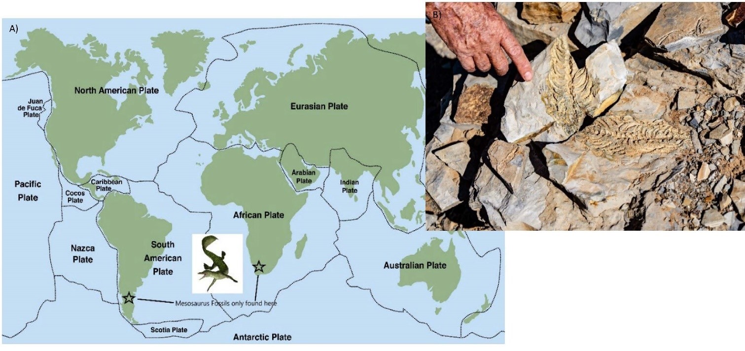
(a) Distribution of mesosaurus fossils; mesosaurus lived in a freshwater environment about 230 million years ago. (b) Mesosaurus fossil.
Let us apply critical thinking associated with the scientific method to see which possibility we should accept:
- If mesosaurus could swim across an ocean, why didn’t it swim to other locations around the globe? The fact that this fossil is found only in these locations in rocks older than the time of the postulated breakup of Pangaea means that this possibility must be discarded.
- There is ample evidence in nature and the rock record that animals will evolve similar traits when those traits are the most advantageous to survival or reproduction. For example, the thylacine, or Tasmanian tiger (believed to have gone extinct in the 1930s), evolved stripes like a tiger but is actually a marsupial! However, there are usually enough differences to be able to distinguish between otherwise similar fossils. Therefore, fossils evolving to look exactly alike is highly unlikely.
- This is the most plausible possibility. It accounts for fossils’ localized distribution, for their age, and for morphology and therefore must be accepted.
The Discovery of Plate Tectonics
It was not until the 1960s , during a time of exploration of the seafloor using new sonar technology, that plate tectonics gained prominence. Harry Hess and Robert Dietz were part of missions to map the seafloor using sonar (sound navigation ranging, which originally made this term an acronym) and discovered mid-ocean ridges. Both advanced the idea that mantle material oozed out of these mid-ocean ridges, creating new seafloor crust (oceanic crust), which cooled and spread out on opposite sides of the ridge. A mechanism for continental drift was thereby provided. Hess and Dietz also postulated that the newly created rocks eventually travel to an ocean trench, where they are destroyed and recycled into the mantle.
However, the clincher for plate tectonics came later in the decade, when one of the predictions of the new theory was confirmed. Frederick Vine and Drummond Matthews hypothesized that if Hess and Dietz were correct, then there should be magnetic reversal “stripes” recorded on the seafloor. Furthermore, these stripes should be in the same sequence and equidistant from and on opposite sides of the mid-ocean ridge (the spreading centre). This hypothesis is based on the fact that Earth’s magnetic field undergoes irregularly timed reversals every 500,000 years on average. The reversal of the magnetic field means that what was the magnetic south pole would reside over the geographic north of the planet and what was the magnetic north pole would be over Antarctica! These reversals are recorded in the rocks that form during that time because the magnetic minerals will be aligned according to the prevailing magnetic field. Their alignment becomes locked in when the minerals crystallize as the rock cools and is unaffected by subsequent reversals.
Vine and Matthews set out to test this prediction by passing a sensitive magnetometer, suspended from a ship, over the seafloor to read the magnetic polarity of the rocks below. The current orientation of Earth’s magnetic field would be read as a positive (+) and the reversal read as a negative (–). Therefore, the rocks being formed now at the mid-ocean ridge should be “+” with “–” in rocks at some distance away from the centre. Their experiment confirmed exactly this: the seafloor is indeed magnetically “striped,” confirming Hess and Dietz’s theory, which in turn confirmed continental drift (Animation 2.1).
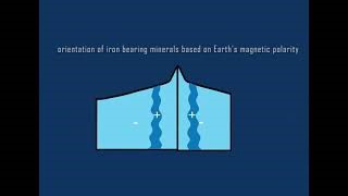
Magnetically “striped” seafloor is created at a mid-ocean ridge (spreading centre) when the magnetic minerals in cooling rock record the orientation of Earth’s magnetic field. This orientation is reversed during periods of periodic polar reversals. Animation produced by Quinn Doherty. Click on the image to load the animation.
As we shall see in the next sections, the theory of plate tectonics is considered unifying because it explains the occurrence and distribution of earthquakes, volcanoes, island arcs, deep-sea trenches, and rift valleys.
2.2 The Engine of Plate Movement
One of the key problems with Wegener’s continental drift hypothesis was identifying the force or engine that could drive such a process. However, with the discovery of the layering of the planet and the scientific inference of convection in the mantle, driven by Earth’s internal heat, it was determined that that engine was convection.
To understand how convection works in the mantle, think about how water boils. When placed on a stove, water at the bottom of the pot becomes hot and starts to rise. This happens because the water molecules are in a more excited state, due to the energy input, causing them to vibrate more (see Animation 2.2). This increase in vibration causes the molecules to space out, reducing the density of the hot water. The lowered density causes the hot (excited) water to rise in relation to the colder, denser water at the top of the pot. As the excited (hotter) water molecules travel from the bottom of the pot (more precisely, the water–stove boundary) to the top, they redistribute the heat they have gained by hitting the less excited (colder) water molecules. Therefore, by the time the water reaches the top of the pot, it loses heat — which is actually a manifestation of the lowered excitement of those molecules — and becomes denser. The cooler water now starts to sink toward the bottom of the pot to be reheated, thus repeating the cycle and creating a convection current. This convection current can be seen in the “rolling” boiling action when water is heated to 100 °C (Animations 2.2a and b).

Click on the image to load the animation. Excited water molecules vibrate more when heated and thus expand, reducing density.
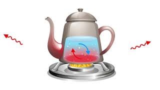
Click on the image to load the animation. Convection currents in boiling water.
Even though the rocky material in the mantle does not have low viscosity like water, it still behaves like a fluid in its semi-solid state, developing convection currents in response to a heat source. At the mantle–core boundary, the mantle is heated, causing its material to rise in the same way as do the excited water molecules in boiling water. As it rises, it redistributes the heat, becoming cooler and denser. When it reaches the lithosphere–mantle boundary, the rising column of mantle material starts to move sideways, dragging the plates along like sticks floating in a river. This is what causes the plates, and thus the continents, to move around the globe! As the mantle material continues to cool, it becomes denser and starts to sink, eventually returning to the mantle–core boundary to be reheated, creating a convection current (Figure 2.3).
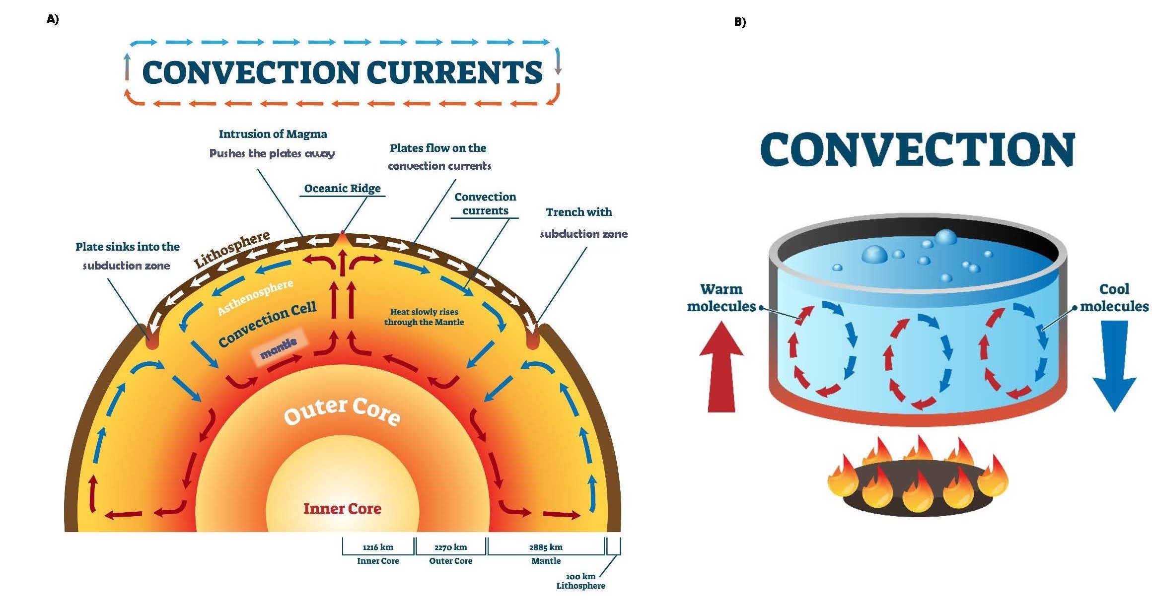
The presence of a convection current in the mantle was the missing component of Wegener’s continental drift hypothesis (at the time) and is now the cornerstone of the theory of plate tectonics. The theory of plate tectonics is now highly regarded and has survived many attempts to disprove it, which leads to it being treated almost like fact. However, as we have seen earlier in this book, “fact” suggests an end to scientific investigation, and there is still much more to learn about Earth’s interior. So far, we have been able to drill down only 12.2 km deep in the crust, less than 10% of the way to the centre of Earth!
2.3 Plate Interactions and Geologic Phenomena
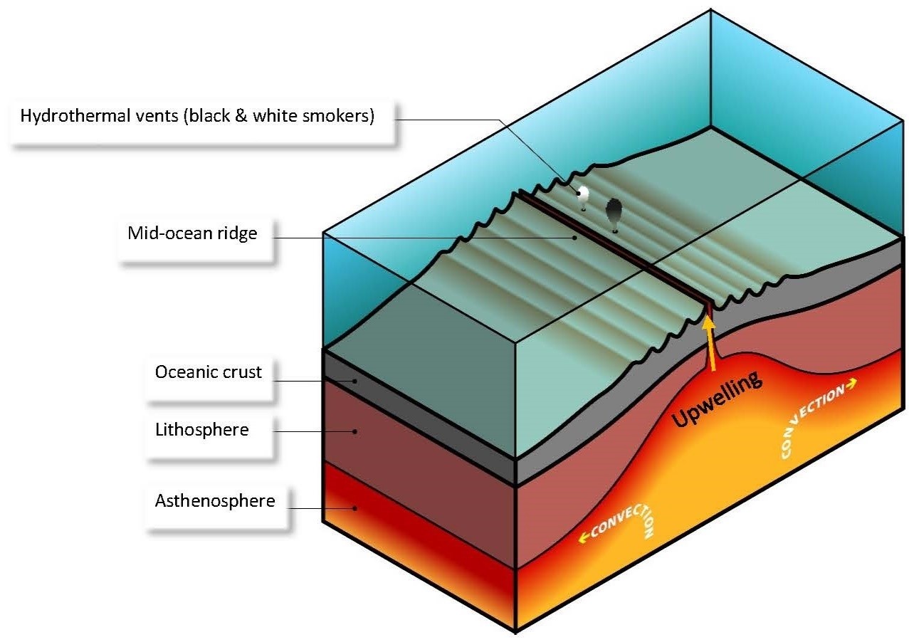
Plate tectonics is a unifying theory because it is elegant — that is, it explains the occurrence of several geologic phenomena and the processes that cause them. Many geologic phenomena arise out of the interactions between plates. As convection causes the mantle to rise, it is incident on the lithosphere and begins to move sideways. This sideways movement breaks the lithosphere, creating plates, with new rock being added to the plates as the mantle material solidifies (crystallizes) into rock. This new rock is formed by mantle material upwelling in the space left by the “break” in the lithosphere, creating mid-ocean ridges. For this reason, mid-ocean ridges are also called spreading centres (Figure 2.4).
The plates that have been created float on the mantle beneath them and move as a result of the mantle, causing them to bump into, move away from, and slide past each other. Where they bump into each other, the plates form convergent boundaries; where they move away from each other, they form divergent boundaries; and where they slide past each other, they form transform boundaries.
Convergent Plate Boundaries
As the plates are set in motion by the convection currents in the mantle (specifically the “sideways”-moving part of the current), they will inevitably meet or “bump” into each other at a convergence zone, where plate is destroyed and recycled in the mantle. This type of plate interaction results in several geologic phenomena depending on the types of rock in the plate. There are essentially two types of lithosphere: continental and oceanic. Continental crust has rock that has a higher silica content and lower metallic content than rocks in oceanic crust. This makes it less dense than oceanic crust and, as we will see, this difference in density influences how plates interact at convergent boundaries.
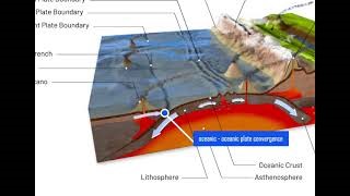
Oceanic to Oceanic Plate Convergence When two plates with oceanic crust collide, the plate that is less dense rides up and over the denser plate, causing subduction. That is, the denser plate is subducted under the less dense plate, gets pushed into the mantle, and is eventually completely melted and recycled at the mantle–core boundary. The subduction zone is marked by a deep-sea trench that is perpendicular to the movement of the subducted plate (Animation 2.3). Other important geologic features and phenomena occur as follows:
Click on the image to load the animation.
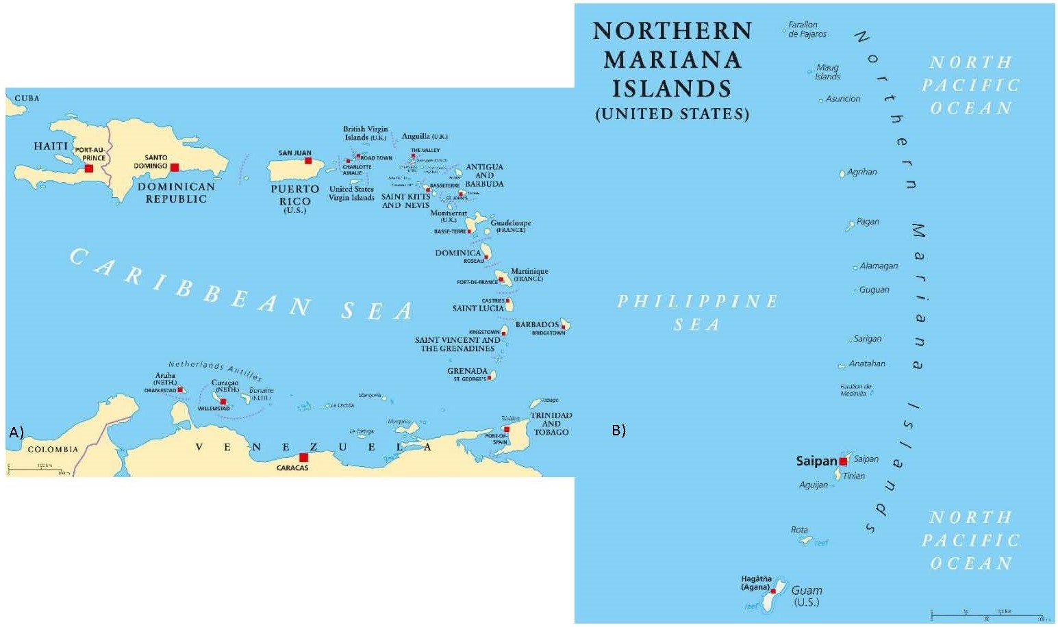
- As the oceanic crust travels from the spreading centre to the convergence zone over millions of years, detritus from the shells and skeletons of marine creatures accumulates and is eventually transformed into rock through a process of lithification. These shells and skeletons are carbonates (–CO3), which results in the rock formed from them having a lower melting point than the siliceous (silica-present) crust rocks. Rocks of different compositions melt at different temperatures. Rocks that have a higher silica content melt at a lower temperature than the rocks with lower silica content (and high metallic content) and are also therefore melted during subduction. This melting creates a plume of lower-density, gaseous (from the carbonate rocks’ giving off CO2) magma, which rises from the subducted plate under the overriding plate and which eventually erupts onto the subducting plate. The erupted material cools into new rock that has a high silica content and accumulates into mounds called volcanoes. The volcanoes eventually build up enough to break the surface of the water, where they become volcanic islands. The convergence zone becomes dotted with these islands, which are parallel to the convergence boundary creating what is known as a volcanic island arc. Examples of volcanic island arcs are the Mariana Islands in the Pacific Ocean and the islands of the Lesser Antilles in the Caribbean. Volcanic island arcs occur only on the subducting plate. As the plates move, these islands can become incorporated with others (or with continents) to create continental landmasses. These continental landmasses are therefore made up of rocks with lower density than those making up oceanic crust. It is no wonder that about 80% of all the world’s volcanoes are located along convergence zones on the subducting plate!
- The detritus from the marine creatures accumulate as sediment before turning into rock. This sediment is “scraped” off of the subducted plate and added to the leading edge of the subducting plate, creating an accretionary prism. The island of Barbados is the part of an accretionary prism that is exposed above sea level! Notice its position in relation to the other islands in the volcanic island arc (Figure 2.5).
The red squares indicate active volcanoes
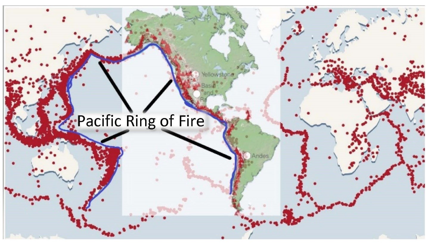
- Earthquakes are caused by the buildup and sudden release of energy in the plates. The buildup of energy is in the form of pressure due to friction between the moving plates. At convergent boundaries there is immense pressure built up from compressive forces, leading to frequent and sometimes large earthquakes with shallow (0–60 km) and deep (over 700 km) foci. In fact, if we plot the epicentres all of the earthquakes that have ever occurred on Earth, the vast majority of them would plot along the margins of convergent plate boundaries! Furthermore, earthquakes with the deepest foci occur only along subduction zones because friction is still built up (and released) along the surface of the subducted plate and the upper parts of the mantle.
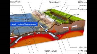
Oceanic to Continental Plate Convergence When oceanic plates converge with continental plates, the oceanic plate is subducted because it is denser than the continental plate. As we saw previously with the preferential melting of subducted oceanic plates, continental plates have rocks with high silica contents, which makes them less dense. This causes the continental plate to ride up and over the oceanic plate, which leads to the oceanic plate’s subduction into the mantle. The subducted plate is eventually completely melted and recycled at the mantle–core boundary. Other important geologic features and phenomena occur as follows (Animation 2.4):
Click on the image to load the animation.
- The rocks in the continental landmass buckle and bend at the convergent zone, leading to folded mountain belts that parallel the convergence zone. This process of mountain building through plate collisions is called orogeny. The Andes in South America are an example of this type of orogeny.
- Preferential partial melting of the subducted plate creates a plume of high-silica gaseous magma. This magma rises through the continental crust to erupt at the surface, building up volcanoes that are associated with the folded mountain belt/chains. An example of this association is that of the Cascades volcanoes in the Rocky Mountains.
- Deep-sea trenches parallel to the convergence zone essentially form the outline of this zone.
- An accretionary prism is also built up, in the same way as in oceanic to oceanic plate convergence.
- Frequent shallow and deep earthquakes result, with deep-focus earthquakes occurring only at convergence zones (Figure 2.6).
Distribution of earthquake epicentres recorded between 1978 and 1987 with the location of volcanoes in the Rocky Mountains (Cascades) and Andes Mountain ranges. The red triangles indicate volcanoes; the red dots indicate earthquake epicentres
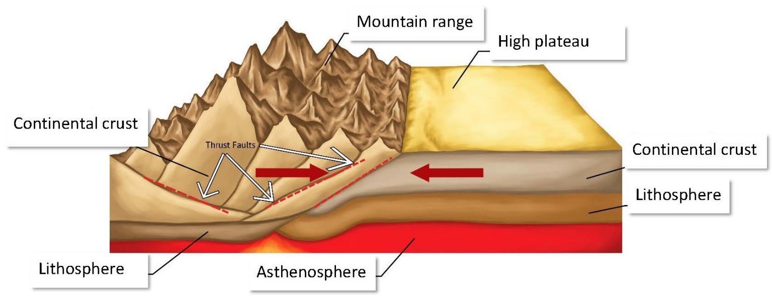
Continental to Continental Plate Convergence When two plates with continental rock collide, the plate with relatively lower density will ride up and over the denser plate. However, because continental plates have high silica contents, that plate will not be subducted. This leads to a doubling or thickening of the crust, resulting in turn in very high mountain ranges that parallel the convergence zone. The Himalaya Mountains, which include the highest mountain peak in the world (Mount Everest), are an example of a mountain belt associated with this type of plate collision (Figure 2.7).
Frequent earthquakes result, mostly shallow (0–60 km deep). Most of these earthquakes are associated with the thrust faults that develop due to the intense compressive forces at this type of convergence zone. The earthquakes are usually tied to the continuous orogeny taking place, with the aftermath revealing higher mountains. That is, it is the process of incremental slips along the thrust faults that results in the buildup of the mountains, and each slip causes an earthquake.
Divergent Plate Boundaries
This type of plate boundary occurs at mid-ocean ridges or spreading centres and can occur between continental lithospheres or between oceanic lithospheres. Plate is created at these boundaries.
Oceanic Plate Separation As upwelling occurs in the mantle due to the convection currents, the incident movement causes the plate to break and separate along a mid-ocean ridge. This breaks one larger oceanic plate into two separate pieces that move in opposite directions, away from each other. New rock solidifies from the magma being upwelled in the gap left between the separating plates (Figure 2.8). The new rock is essentially added to the two pieces, to be eventually destroyed and recycled at a subduction zone. The size of this zone is about 1 km in width but can be several thousand kilometres long. The Mid-Atlantic Ridge is a mid-ocean ridge that separates the North American and South American Plates from the Eurasian and African Plates and is about 16,000 km long! Other important geologic features and phenomena occur as follows:
- Shallow earthquakes occur with less frequency than at convergence zones and are usually associated with intra-plate transform fault movement due to different rates of plate separation along the divergent plate boundary. The different rates of movement create transform faults along which energy builds up due to friction. When this energy is released, it creates earthquakes.
- Most eruptions of lava along mid-ocean ridges are through fissures; however, frequent eruptions can lead to the creation of volcanoes, through which the magma can be erupted as lava.
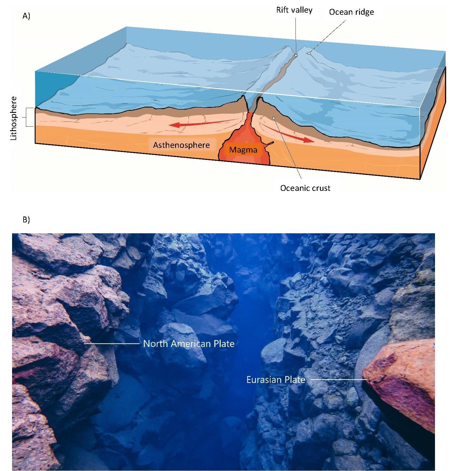
(a) Features at a divergent oceanic plate boundary. (b) Underwater view of the Mid-Atlantic Ridge
Continental Plate Separation Separation occurs in continental crust due to upwelling and incident lateral forces caused by the “sideways” movement of the mantle from convection. This pulls the crust apart, creating zones of weakness through which mantle material (magma) rises; this material solidifies into rock and is added to the separating plates. This zone of separation is marked by a rift valley that is tens of kilometres in width. The rift valley has a step-like morphology in cross-section, resulting from the normal faults in the continental rocks (Figure 2.9). An example of this type of plate separation is the Great Rift Valley, created by the East Africa Rift. Other important geologic features and phenomena occur as follows:
- Shallow earthquakes are associated with the normal faults.
- Fissure and volcano eruptions occur at the spreading centre.
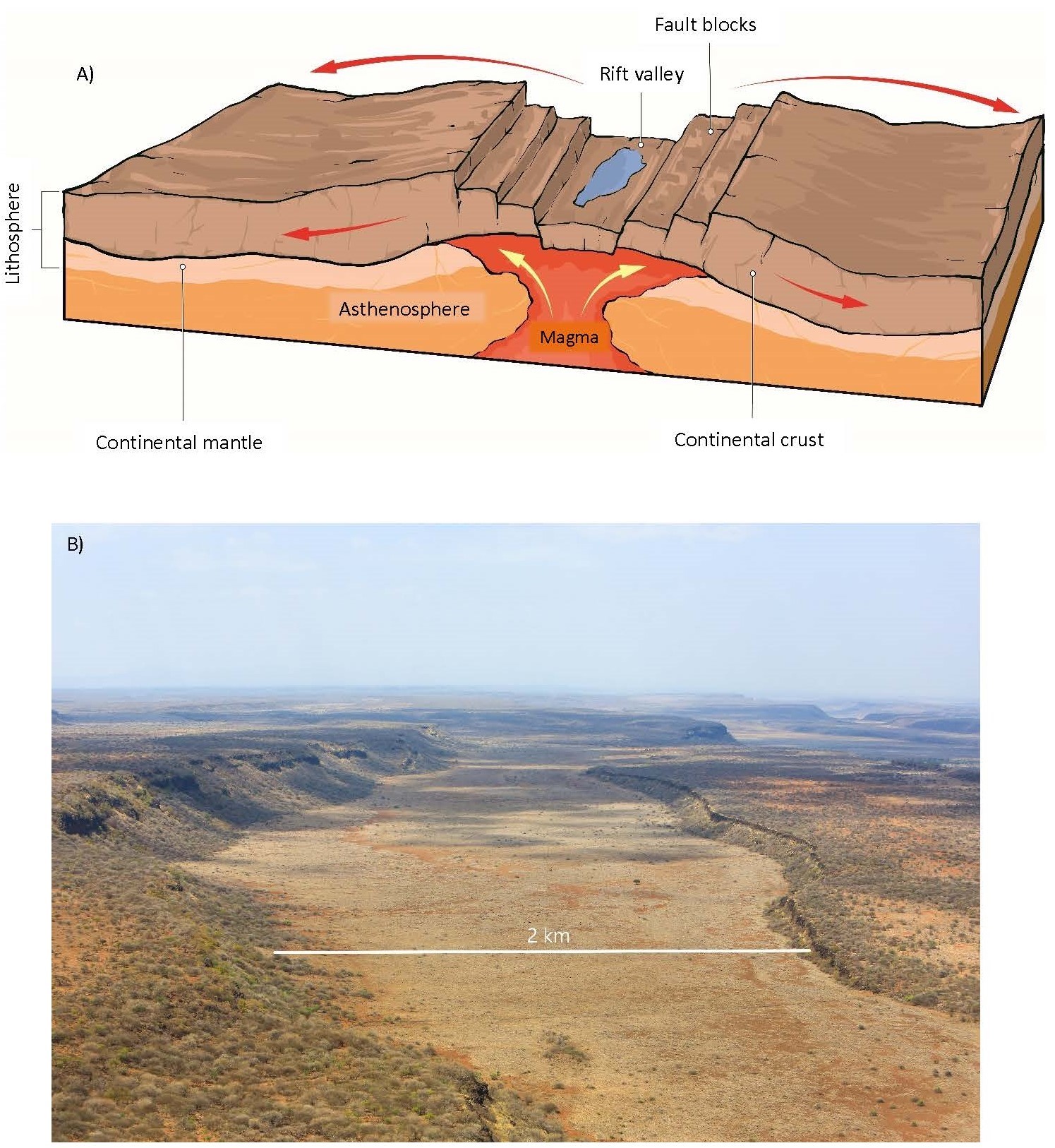
(a) Features at a divergent continental plate boundary. (b) The East Africa Rift valley (Great Rift Valley) in Kenya
Transform Plate Boundaries
The lateral movement of the mantle incident on the lithosphere due to convection not only causes movement of plates away from and toward each other, but also causes them to slide past each other. This type of plate movement is a result of shearing forces that originate in the movement of the mantle on which the plates “float.” The shear forces essentially create transform faults, along which movement occurs between two plates, resulting in a transform plate boundary. Because there is no subduction or rifting, no plate is created nor destroyed at these boundaries. However, it must be noted that there may be localized zones of orogeny and miniature rift valleys due to “jogs” or bends in the fault line (Figure 2.10).
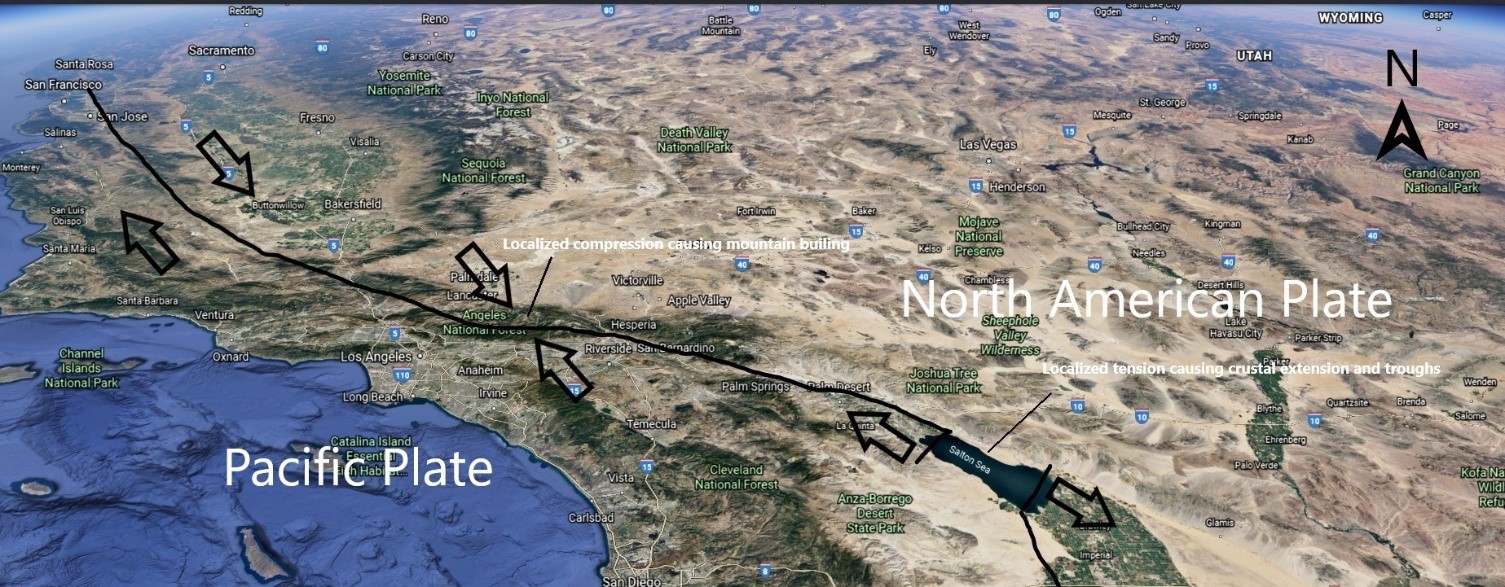
Localized formation of rift valleys and mountain ranges along the San Andreas transform fault boundary. Arrows indicate the relative motion of the plates
Part of the boundary between the Pacific Plate and the North American Plate is a transform fault or plate boundary known as the San Andreas Fault (Figure 2.11).
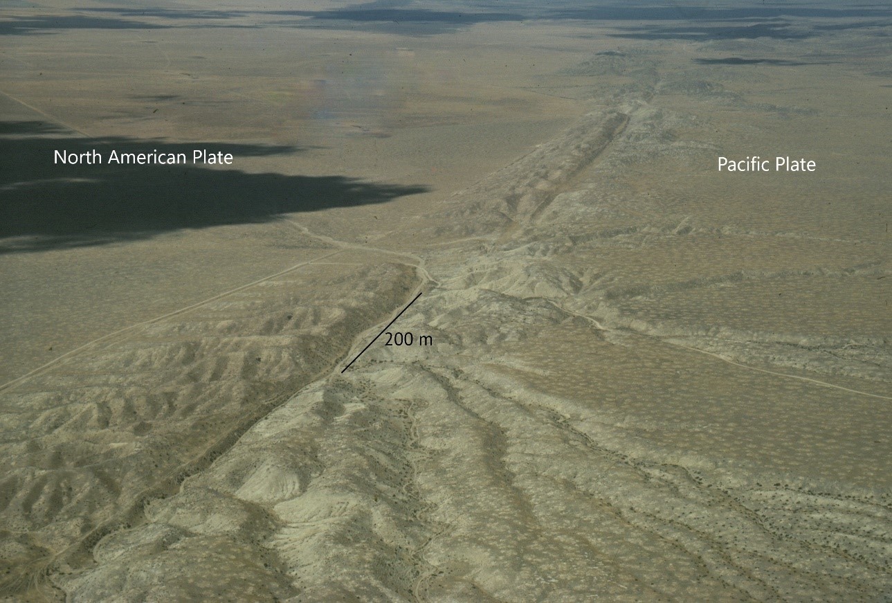
Picture taken looking southeast
The fault is not a straight line of division between the two plates but an irregular one. This creates localized areas where compressive or tensile forces dominate due to the direction of the “bend” in the fault line and the relative motion of the plates. Other important geologic features and phenomena occur as follows:
- Frequent shallow earthquakes occur due to the buildup and release of energy from friction between the plates, arising from their relative motion due to shearing forces.
- Localized mountain ranges and rift valleys 1–10 km in size are created due to bends in the transform fault.
- Smaller transform faults occur at spreading centres due to differential rates of movement of the plate. The movement of the plates away from mid-ocean ridges (spreading centres) is not uniform along the divergent boundary. Even though all of the plate is moving in the same direction, different parts are moving at different speeds. This creates a shearing force within the plate, giving rise to transform faults that are technically transform plate boundaries (Figure 2.12). These shearing forces also account for most of the earthquakes (shallow, 0–5 km deep) that occur along divergent plate boundaries.
2.4 The Rates of Plate Movement and Historical Geology
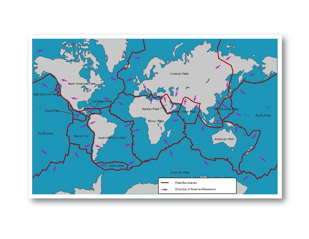
Earth’s lithosphere is broken up into 14 plates that move about while “floating” on the mantle. The relative movements of these plates are subject to the movement of the mantle below due to convection. A plate is named based on the continental landmass that it carries or the major ocean that it underlies. Note in Figure 2.13 that the visible outline of a continent does not delineate a plate’s boundaries: the plate boundaries extend beyond this outline, submerged under the oceans. The speed of movement ranges from 1 to 15 centimeters per year, which is about the rate of growth of your fingernails.
Several current methods of accurately measuring plate movements and rates have confirmed predictions that are consistent with plate tectonics. One method is the use of global positioning systems (GPS) that bounce signals off of orbiting satellites using the differences in return times for those signals to calculate the global position (Figure 1.14). Even without GPS, one could infer relative plate motions and rates from hotspot volcanism. Hot spot volcanism occurs when superheated magma rises from the mantle–core boundary as a jet or plume and is incident on a plate. This jet of mantle material punches through the lithosphere and erupts at the surface eventually building up into a volcano. When the volcano is visible above sea level, it is termed a volcanic island and can build up into significant landmasses like Iceland and the island of Hawaii.

Surface movement is determined from continuous GPS measurements
Using the Hawaiian Island chain as an example, we can infer the history and the rate of movement of the Pacific Plate. The Hawaiian Islands were created as the Pacific Plate migrated over the hotspot plume located under the largest island of Hawaii. The islands of Maui, Molokai, and Oahu were once located over the hotspot and have since migrated away as the plate moved to the northwest. Essentially, those three islands are extinct volcanoes, with Hawaii being the only active one. Also, notice the change in size of the islands the farther away they have migrated from the hotspot (Figure 2.15). They have become smaller due to erosive forces outpacing the volcanic forces that caused the island to be built up in the first place.
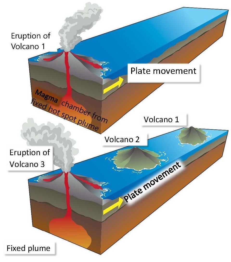
The age of the rocks associated with each island in the chain can be dated. This date can be used together with the relative distance of each island from the current hotspot to determine the average rate of movement of the Pacific Plate that carries these islands.
Geologists have been able to piece together the historical positions of the continents by “rewinding” the rates and directions of plate movements in concert with faunal and floral successions and rock assemblages in the rock record.
The seafloor (or oceanic lithosphere) is made up of higher-density rocks than continental lithosphere and is easily subducted and destroyed at convergence boundaries. This leads to the seafloor renewing itself approximately every 200 million years. Continental lithosphere is not easily subducted, due to its lower density, and therefore carries rocks that can be much older than any oceanic lithosphere. In this regard, continental lithosphere will record a longer geologic history, which can be used to reconstruct the ancient positions of the continental landmasses. This process has revealed the following succession of assemblies and breakups of the continents:
- Rodinia The earliest known continent, Rodinia, was formed about 1 billion years ago and is understood mainly through the paleomagnetism and the orogenies of mountains belts that have been significantly eroded, leaving behind only their “roots” as evidence of the assembly of this supercontinent. Rodinia lasted about 150 million years after complete assembly and started to break up about 750 million years ago.
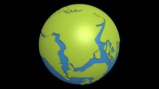
- Pangaea Between 740 and 600 million years ago, Pangaea started to assemble through the aggregation of Gondwana (today’s South America, Africa, and Antarctica) and was completed when Gondwana was joined with Laurasia (today’s North America, Greenland, and Eurasia). Pangaea started to break up about 200 million years ago, resulting in the orientations of the continents we see today (Animation 2.5).
Click on the image to load the animation.
In the future, possibly another 100 million years or so from now, all of the continents will be rejoined in another supercontinent.
The process of movement of segments of Earth’s crust on the mantle resulting in several geologic phenomena
The plates that float on Earth’s upper mantle
The movement of continents carried with plates of Earth’s crust
Rocks that were laid down in a specific sequence, indicating a specific sequence of geologic processes acting in specific depositional environments
Grouping of fossils in the rock record
The large-scale fissure in the Earth’s crust separating divergent plates
An upward and downward cycle of movement caused by the flow of heat energy in a system
A meeting of plates where plates move toward each other
Margins at which plates move away from each other on either side
A meeting of plates that move parallel to each other
A region in which plates meet
The less dense portion of Earth’s crust, with higher silicate content than oceanic crust
The denser, more metallic portion of Earth’s crust with lower silicate content than continental crust
The riding up of a less dense plate over a denser plate, which is then pushed into the mantle and eventually recycled
Transformation of sediments into rock
A series of volcanic islands parallel to a convergence boundary
The process of mountain building through plate collisions
A depression in Earth’s crust created by the separation of continental plates
A meeting of plates at which the plates slide past each other
The rising of superheated magma from the mantle–core boundary as a jet or plume
A volcano formed in water that is visible above sea level